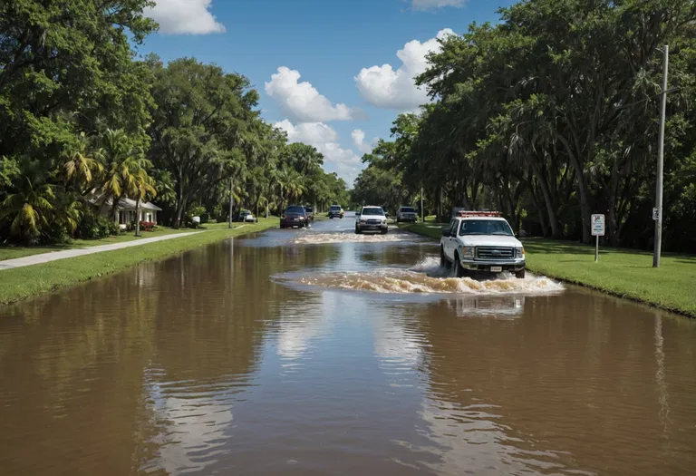
A flood watch is a heads-up rather than a guarantee — and millions of people across South Florida are living through exactly what that distinction means this week. After more than a foot of rain soaked parts of Broward and Miami-Dade counties, the National Weather Service (NWS) kept a flood watch in effect through Thursday evening, signaling that conditions were favorable for flooding even before streets turned into rivers. Understanding what a flood watch actually means — and how it differs from the warnings and emergencies that follow — can be the difference between staying safe and getting caught off guard.
What a Flood Watch Actually Means
The National Weather Service boils its flood alerts down to two simple commands: a flood watch means "be prepared," and a flood warning means "take action." A flood watch is issued when conditions are favorable for flooding to develop — heavy and persistent rain, ground already saturated from earlier storms, or rivers and streams primed to rise — but flooding itself is not a certainty at the moment the watch goes out. The NWS is explicit on this point: a watch does not mean flooding will happen, only that it is possible.
Think of a flood watch like ingredients set out on a counter before a meal is cooked. The conditions that produce flooding are present, but forecasters are still watching to see whether they combine into a full-blown event. Watches are typically issued 12 to 36 hours — sometimes longer — before a potential flood, which gives residents time to prepare rather than react.
How Forecasters Decide to Issue a Flood Watch
A flood watch does not appear out of thin air. Meteorologists and hydrologists at local NWS forecast offices track a combination of signals: how much rain is expected, how quickly it will fall, whether the ground is already waterlogged from prior storms, and how fast rivers and creeks are likely to rise. Forecasters pull from radar, ground-based rain gauges and river gauges, and they lean on the NWS's streamflow and hydrologic models to project how quickly waterways will crest. All of that feeds into the decision to raise a watch for a specific county or corridor.
In South Florida this week, forecasters pointed to an El Niño-driven wet pattern that had primed the region for trouble. The Miami Herald reported that forecasters had promised a wet winter for Florida because of El Niño, and this week delivered another drenching. With additional heavy rain possible in the Miami and Fort Lauderdale area through November 19, the flood watch signaled that the risk had not passed even after the first round of downpours.
It also helps to know the two broad flavors of a flood watch. An areal flood watch covers widespread flooding that develops gradually, often from prolonged rain falling over hours or even days. A flash flood watch covers the rapid, dangerous flooding that can strike within minutes to a few hours, usually from intense rainfall in a short burst. Flash flooding is the more dangerous of the two because it leaves almost no time to respond.
Flood Watch, Warning and Emergency: The Escalating Alerts
Understanding a flood watch requires seeing where it sits in a step-by-step escalation of NWS alerts. The watch is step one — the early signal. When flooding becomes imminent or is already underway, the NWS upgrades the alert to a flood warning, which means "take action." That is the moment to move to higher ground, avoid low-lying roads and follow instructions from local officials.
For rapid-onset events, a flash flood warning carries an even more urgent tone: life-threatening flash flooding is occurring or about to begin. At the top of the scale sits the rare flash flood emergency, reserved for catastrophic flooding that poses a severe threat to life and property. Each rung up the ladder means less time to act and greater danger — which is precisely why a watch is so valuable. It buys hours of lead time that warnings and emergencies simply cannot.
The hierarchy is the same across the country, but the stakes shift with the terrain. In flat, low-lying, canal-lined South Florida, even moderate rain can overwhelm drainage quickly and turn neighborhood streets into hazards. That is why local officials treat a watch as a cue to pre-position resources and warn residents, rather than waiting for a warning to appear.
South Florida's Flood Watch: A Foot of Rain and Counting
The current watch is playing out in real time across southeast Florida. More than 12 to 15 inches of rain fell in parts of the region in roughly 24 hours, with Broward County reporting totals exceeding 14 inches. The downpours turned roads into impassable waterways, stranded vehicles and sent water into homes on Tuesday night, according to CNN, while NBC Miami tracked a live flood watch in the aftermath of the deluge.
The impacts cascaded quickly. Broward County schools closed, flights were grounded or disrupted at area airports, and traffic cameras captured cars slogging through floodwater along major corridors. The NWS warned that heavy to excessive rainfall would likely bring flash and urban flooding impacts along the I-95 corridor from St. Augustine down to Palm Beach. In Hollywood, Florida, torrential rain turned dangerous as additional downpours threatened to pile onto what had already fallen.
What to Do When a Flood Watch Is Issued
A watch is your window to prepare, not your cue to panic. Emergency management guidance is consistent: use the lead time to secure your home, move valuables to higher floors, charge phones and other devices, and review evacuation routes. The NWS and the CDC both stress preparing before the water arrives — securing hazards in and around the home and being ready to turn off utilities if flooding threatens. Signing up for wireless emergency alerts and following your local NWS office keeps the next step — a warning or emergency — from catching you off guard.
The single most important safety rule, repeated by the NWS for years under its "Turn Around, Don't Drown" campaign, is to never drive through flooded roadways. Most flood-related deaths in the United States happen in vehicles: the NWS notes that just six inches of fast-moving water can knock an adult off their feet, and 12 inches of moving water can carry away a small car. During a watch, the smartest move is to monitor forecasts and local alerts so you are not on the road when a warning or emergency takes effect.
The Bottom Line: Flood Watch Essentials
- A flood watch means "be prepared" — conditions are favorable for flooding, but flooding is not guaranteed.
- A flood warning means "take action" — flooding is imminent or already happening.
- Watches are typically issued 12 to 36 hours ahead, giving residents time to plan.
- Flash floods strike within minutes; areal floods build gradually over hours or days.
- South Florida is under a flood watch through Thursday evening after 12 to 15 inches of rain, with more possible.
- Never drive through floodwater — most flood deaths occur in vehicles.