

The island of Oahu, Hawaii faced its worst flooding in two decades in March 2026, with floodwaters lifting homes off their foundations, floating cars out of driveways, and forcing the evacuation of more than 5,500 residents. As rescue teams worked to save over 200 people from rising waters, meteorologists identified the culprit: a powerful "Kona low" weather system that dumped 8 to 12 inches of rain on parts of the island in just days. But what makes flash floods so dangerous and sudden, and why is Hawaii particularly vulnerable to these devastating events?
How Flash Floods Form: The Science Behind Rapid Inundation
Flash floods represent one of nature's most sudden and dangerous weather phenomena, defined by the National Weather Service as flooding that begins within 6 hours—and often within 3 hours—of heavy rainfall or another triggering event. Unlike regular flooding that develops gradually over days or weeks, flash floods strike with little warning, transforming dry creek beds into raging rivers in minutes.
The mechanics behind flash flooding involve three key factors: precipitation intensity, soil conditions, and topography. When rain falls faster than the ground can absorb it—a rate meteorologists call the "infiltration capacity"—water begins to pool on the surface. In urban areas with concrete and asphalt, this happens quickly as impermeable surfaces prevent water from soaking into the ground. In natural settings, already saturated soil from previous rainfall creates similar conditions.
"Flash floods occur when heavy rainfall exceeds the ability of the ground to absorb it," explains NOAA's Severe Weather 101 educational resource. "They also occur when water fills normally dry creeks or streams or enough water accumulates for streams to overtop their banks." This rapid accumulation can happen from intense thunderstorms, hurricane remnants, or—as in Hawaii's case—persistent low-pressure systems known as Kona lows.
The Hawaii Timeline: How March 2026's Catastrophe Unfolded
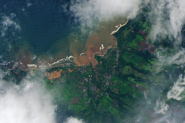
The sequence of events that led to Hawaii's worst flooding in 20 years began with the development of a Kona low northwest of the islands. These subtropical cyclones, named for their typical formation west of the islands ("kona" meaning leeward in Hawaiian), are known for producing heavy rainfall and strong southwesterly winds. By March 20, 2026, the National Weather Service had issued flash flood warnings for Oahu as the system approached.
Over the next 48 hours, the situation escalated rapidly. Rainfall totals reached 6 to 12 inches across Oahu's northern half, with the already saturated ground from previous weekend storms unable to absorb the deluge. By March 21, emergency officials issued evacuation orders for 5,500 residents in the Waialua area north of Honolulu, warning of possible dam failure and life-threatening conditions.
"Rising floodwaters lifted homes and cars and triggered evacuation orders for some 5,500 people north of the state's capital city, Honolulu," reported the BBC. Rescue teams from multiple agencies worked through the night, ultimately saving more than 200 people from rooftops and vehicles. The flooding created scenes reminiscent of a disaster movie, with roads washing away completely and neighborhoods becoming isolated islands.
Why Hawaii's Geography Makes It Flash Flood Prone
Hawaii's unique geography creates perfect conditions for flash flooding, as explained by the Hawaii Emergency Management Agency: "Hawaiʻi's natural environment is conducive to flash flooding. Storm fronts and trade winds come in contact with Hawaiʻi's tall mountains, pushing the air upward." This orographic lifting—when air is forced to rise over mountains—cools the air mass, causing moisture to condense and fall as heavy rainfall on windward slopes.
The steep volcanic terrain of the Hawaiian Islands accelerates water movement, creating what hydrologists call "flashy" watersheds. Water runs off quickly rather than soaking in, funneling into narrow valleys and streams that can transform from trickles to torrents in minutes. Urban development has exacerbated this natural vulnerability by replacing permeable vegetation with impermeable surfaces, reducing the landscape's ability to absorb rainfall.
Climate change adds another layer of risk. Warmer atmosphere holds more moisture—approximately 7% more water vapor per 1°C increase—leading to more intense rainfall events. The March 2026 Kona low arrived amid already elevated ocean temperatures around Hawaii, providing additional fuel for the storm system.
The $1 Billion Wake-Up Call: Assessing Damage and Recovery
Initial damage assessments from the March 2026 flooding paint a staggering picture. Hawaii Governor Josh Green estimated total costs could exceed $1 billion, including damage to airports, schools, roads, homes, and medical facilities. On Oahu alone, hundreds of properties suffered damage, with some houses completely destroyed by floodwaters or the accompanying mudslides.
"Red volcanic mud coats homes after Hawaii's worst floods," reported The Guardian, describing the cleanup challenge facing residents. This distinctive red mud, rich in iron oxides from Hawaii's volcanic soil, seeped into homes, coated roads, and contaminated water supplies. The cleanup process revealed another hazard: floodwaters had mobilized pollutants from agriculture, construction sites, and overwhelmed wastewater systems.
Beyond physical damage, the flooding exposed vulnerabilities in Hawaii's infrastructure and emergency response systems. Aging dams, some over a century old, came under scrutiny as engineers assessed their ability to handle future extreme rainfall events. The event also highlighted socioeconomic disparities, with lower-income communities in flood-prone areas suffering disproportionate impacts.
Flash Flood Safety: What You Need to Know to Stay Protected
Understanding flash flood risks and proper response protocols can mean the difference between life and death. The most critical rule: never attempt to drive or walk through floodwaters. As little as six inches of moving water can knock over an adult, while just one foot of water can float most vehicles. Many flash flood fatalities occur when drivers underestimate water depth and force on roadways.
Meteorologists emphasize heeding warnings immediately. A Flash Flood Watch means conditions are favorable for flooding—be prepared to move to higher ground. A Flash Flood Warning means flooding is imminent or already occurring—take action immediately. In Hawaii's March 2026 event, officials used unusually strong language in their warnings, telling residents in threatened areas simply: "Leave now."
Preparation includes knowing your local evacuation routes, having an emergency kit ready, and understanding the flood risk specific to your property. For homeowners in flood-prone areas, flood insurance provides critical financial protection, as standard homeowners policies typically exclude flood damage.
Looking Ahead: Building Resilience in a Changing Climate
The catastrophic March 2026 flooding serves as a stark reminder of Hawaii's vulnerability to extreme weather in a warming climate. Building resilience requires multiple approaches: updating infrastructure to handle more intense rainfall, preserving natural floodplains and wetlands that absorb excess water, improving warning systems, and implementing stricter building codes in flood-prone areas.
Scientists predict that climate change will increase the frequency and intensity of heavy rainfall events in Hawaii, making events like the March 2026 flooding more common. This reality underscores the importance of integrating climate projections into urban planning, emergency management, and infrastructure design.
Community awareness and preparedness form the final layer of defense. As Hawaii residents learned in March 2026, flash floods can transform familiar landscapes into dangerous waterways with astonishing speed. Understanding how these events form, recognizing warning signs, and having a prepared response plan remain essential skills for living in flash flood-prone regions.
Key Takeaways: Understanding Flash Flood Essentials
Flash floods represent one of nature's most rapid and dangerous weather events, striking with little warning and transforming landscapes in hours. Hawaii's March 2026 catastrophe demonstrated how geography, weather patterns, and climate change intersect to create extreme flooding conditions. The event evacuated thousands, caused over $1 billion in damage, and served as a wake-up call about infrastructure vulnerabilities.
Understanding flash flood science—from orographic lifting to infiltration capacity—helps explain why certain areas face greater risks. Preparedness, including heeding warnings, avoiding floodwaters, and proper insurance coverage, provides the best protection against these sudden events. As climate change intensifies rainfall patterns globally, the lessons from Hawaii's worst flooding in 20 years offer valuable insights for communities everywhere facing similar threats.