The polar vortex is back in the headlines in November 2026, and this time meteorologists are reaching for words like "unprecedented" and "record early." A permanent feature of Earth's atmosphere, the polar vortex is a vast area of low pressure and swirling cold air that sits over each pole and reaches its peak strength in winter. Normally, it remains strong and stable through the first half of the cold season, acting as a barrier that locks the Arctic's most frigid air in place. Right now, however, forecasters say it is breaking down weeks earlier than has ever been observed, raising fresh questions about what that could mean for winter weather across the United States, Canada, and Europe. Here is what the polar vortex actually is, how it forms, and why this year's disruption is drawing so much attention.
What Is the Polar Vortex, Exactly?
The polar vortex is a large area of low pressure and cold air that surrounds both of Earth's poles, and it always exists near the poles. It does not simply "arrive" during a cold snap, even though that is how the phrase is often used. According to the National Weather Service, the vortex that matters most for winter weather is a fast-moving band of strong westerly winds encircling the North Pole high in the stratosphere, roughly 10 to 30 miles (15 to 50 kilometers) above the surface. Scientists often describe it as a giant, spinning whirlpool of cold air.
There is an important distinction worth keeping in mind. The stratospheric polar vortex sits far above the weather layer, while a separate tropospheric polar vortex exists lower down, where storms actually form. NOAA stratosphere expert Amy Butler has noted that people often confuse the polar vortex with the polar jet stream, but the vortex is a higher-altitude feature. The two influence each other, and that connection is a big part of why forecasters watch the vortex so closely each winter.
How the Polar Vortex Forms Each Autumn
The polar vortex re-forms every year as the Arctic settles into its long winter night. In autumn, the lack of sunlight over the pole causes temperatures in the stratosphere to plunge while the tropics stay warm. That sharp temperature contrast drives a ring of powerful westerly winds circling the pole from west to east. When this circulation is strong and stable, it behaves like a fence: the coldest air stays bottled up near the pole, and mid-latitude regions such as the United States and Europe remain relatively mild.
When the vortex is strong, the polar jet stream below it also tends to remain tight and fast, which helps keep Arctic air from spilling south. But when the vortex weakens, that fence begins to sag and wobble, and cold air can start to escape toward the mid-latitudes.
What Happens When the Polar Vortex Breaks Down
The most dramatic kind of disruption is called a sudden stratospheric warming, or SSW. It begins when large atmospheric waves traveling upward from the lower atmosphere break over the pole, dumping energy that can warm the stratosphere by tens of degrees in just a few days. That rapid warming slows the vortex's winds, and in the strongest events it can reverse them entirely or split the single vortex into two or more separate lobes.
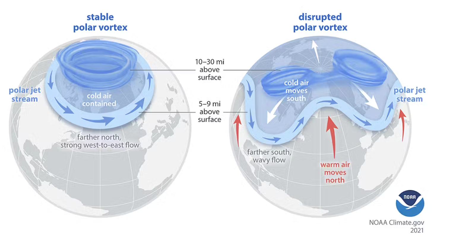
Once the vortex is disrupted, the polar jet stream can become wavy and meander, dipping far south and dragging Arctic air into North America, Europe, or Asia. In other words, a weakening high above the surface is often the first domino in a chain that ends with a bitter cold outbreak at ground level. Importantly, though, not every disruption reaches the surface, which is why an SSW by itself is a signal of risk rather than a guarantee of cold.
Inside the November 2026 Event: A Record-Early Disruption
This fall, that chain appears to be starting far earlier than usual. Here is how the event has unfolded:
- October 2026: Forecast models begin flagging a rare early-season disruption of the polar vortex, well before winter officially begins.
- Late October: NOAA and NASA indicate that an unusually early stratospheric warming is underway, with some models predicting a full reversal of the winds.
- Nov. 3: USA TODAY reports the polar vortex is "doing something extraordinary," with forecast confidence rising that a major disruption is imminent.
- Nov. 5: Wind data show the vortex's daily-mean winds at 60°N tumbling from about 22 meters per second to just 5.4 meters per second in eight days.
- Nov. 9–12: NASA forecasts a complete wind reversal around Nov. 10–12, effectively splitting the vortex into smaller circulations.
- Nov. 20: European forecasters say the vortex could fully break down by this date.
Forecasters described the disruption as "quite rare," warning that it could have "winter-like ramifications on the weather across the U.S. in November and December." Several outlets have called it the earliest major polar vortex disruption in roughly 70 years of records.
What It Could Mean for Winter Weather
A disrupted vortex does not automatically guarantee a brutal cold snap everywhere. Where the cold air ends up depends on how the pieces land, and that is where the forecasts get complicated. AccuWeather cautioned in late October that "what true cold air exists in the pattern will be directed to Siberia, rather than North America" in the near term, a reminder that a weakening vortex can push cold toward other continents instead.
Meanwhile, forecasters in Europe have flagged a higher chance of colder, snowier conditions. The Guardian reported that Europe "could face colder weather" as the vortex weakens, and UK outlets have raised the possibility of significant early-season snow. Adding another layer of uncertainty, a near-record "super" El Niño is developing in the tropical Pacific, and it can tug the jet stream in the opposite direction, influencing where the cold ultimately lands.
Where Things Stand Now and What's Next
As of mid-November 2026, the disruption is ongoing and is widely considered the earliest major polar vortex event in at least 70 years. The key question meteorologists are now watching is whether the disruption "couples" downward from the stratosphere into the lower atmosphere, which is what actually delivers cold air to the surface. If that coupling occurs, cold outbreaks could arrive in the U.S. and Europe in late November and early December. If it does not, the event could fizzle with little effect on everyday weather.
For now, the watchword is uncertainty, but the extraordinary timing alone makes this a winter worth following closely.
The Bottom Line: Key Points to Remember
- The polar vortex is a permanent ring of cold, low-pressure air and strong winds that circles the pole high in the stratosphere, strongest in winter.
- When it is strong and stable, it locks Arctic cold in place; when it weakens or splits, cold air can spill southward.
- A sudden stratospheric warming is the most dramatic disruption, warming the upper atmosphere and reversing or splitting the vortex winds.
- The November 2026 disruption is unfolding weeks earlier than any previously recorded event, with winds reversing around Nov. 10–12.
- Whether it brings bitter cold to the U.S. and Europe depends on whether the disruption reaches the lower atmosphere, and where the cold air gets steered.