
As millions of Americans faced another brutal winter storm in December 2024, the National Weather Service issued new blizzard warnings across multiple states, highlighting the urgent need to understand what these serious alerts actually mean. With sustained winds exceeding 35 mph and visibility dropping to near-zero due to blowing snow, blizzard warnings represent some of the most dangerous winter weather conditions possible—conditions that claimed lives, caused multi-vehicle accidents, and left thousands without power during recent storms.
Understanding Blizzard Warning Criteria: More Than Just Heavy Snow
According to the National Weather Service, a blizzard warning is issued when specific, severe conditions are expected to prevail for at least three hours: sustained winds or frequent gusts of 35 miles per hour or greater, combined with considerable falling and/or blowing snow that frequently reduces visibility to one-quarter mile or less. This official definition emphasizes that blizzards are defined by wind and visibility—not just snow accumulation. "Issued for winter storms with sustained or frequent winds of 35 mph or higher with considerable falling and/or blowing snow that frequently reduces visibility to 1/4 of a mile or less," states the NWS glossary. "These conditions are expected to prevail for a minimum of 3 hours."
This distinction is crucial because many people mistakenly believe heavy snowfall alone constitutes a blizzard. In reality, a winter storm could drop several feet of snow without meeting blizzard criteria if winds remain calm. Conversely, even moderate snowfall combined with strong winds can create genuine blizzard conditions with whiteout situations that make travel impossible and outdoor exposure life-threatening.
Recent Blizzard Warnings: December 2024's Dangerous Reality
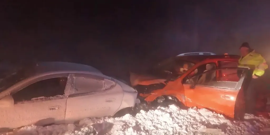
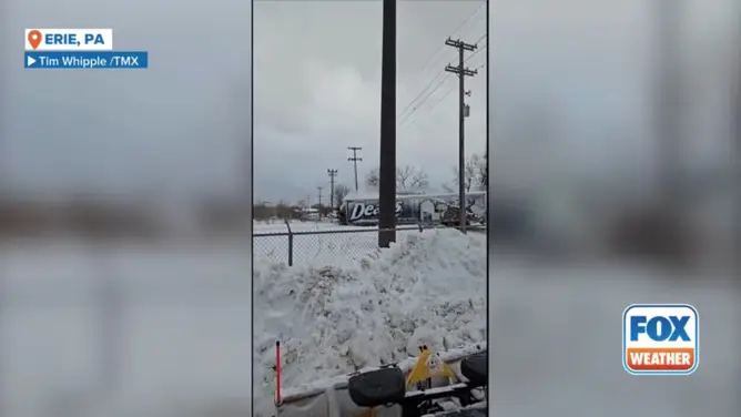
The immediate relevance of understanding blizzard warnings became clear in early December 2024 when a powerful winter storm raced across the United States, prompting new blizzard warnings in portions of West Virginia, Maryland, and Erie, Pennsylvania. According to Fox Weather's December 5 update, "Crashes and power outages are mounting as a powerful winter storm sweeps across the U.S., prompting a new Blizzard Warning in Erie, Pennsylvania." The storm brought life-threatening snow squalls and near-blizzard conditions to regions that had just been slammed by the first significant lake-effect snowstorm of the season.
Travel impacts were severe and widespread. The same storm system contributed to over 11,000 flight cancellations nationwide during the holiday travel period, with the Northeast experiencing particular disruption. "Damaging winds will blow down trees and power lines. Widespread power outages are expected. Travel will be difficult, especially for high profile vehicles," warned forecasters as the system intensified. These real-world consequences demonstrate why blizzard warnings demand immediate attention and preparation.
Blizzard vs. Winter Storm: Decoding the Alert Hierarchy
Understanding the difference between various winter weather alerts can be confusing but is essential for proper response. The National Weather Service maintains a clear hierarchy of winter weather products, each with distinct criteria and implications. According to Weather.gov's warning explanation, a winter storm watch indicates conditions are possible in the next 24-48 hours, while a winter storm warning means significant winter weather is occurring or imminent—typically involving heavy snow (at least 6 inches in 12 hours or 8 inches in 24 hours), ice, or a combination.
A blizzard warning represents a more specific and often more dangerous subset of winter storm warnings. While both require preparation, blizzard warnings specifically address the combination of high winds and reduced visibility that creates particularly hazardous conditions. "A blizzard is defined by visibility and wind, not snow totals," explains one weather service publication. This means that even areas expecting relatively modest snowfall might receive blizzard warnings if winds are strong enough to create blowing snow and whiteout conditions.
Essential Blizzard Safety: What to Do When Warnings Are Issued
When a blizzard warning is issued for your area, immediate action is required. The American Red Cross emphasizes several critical safety measures that can mean the difference between safety and danger. First and foremost: avoid travel if at all possible. "If you must go outside, plan to dress properly. Keep your nose, ears, cheeks, chin, fingers, and toes covered in warm, dry clothing," advises the Red Cross winter storm preparedness guide.
For those who must venture out, preparation is key. Your vehicle emergency kit should include blankets, warm clothing, a first aid kit, boots, water, snacks, a flashlight, a phone charger, and any essential medications. At home, ensure you have adequate supplies to survive without power or the ability to leave for at least three days. This includes non-perishable food, water (at least three gallons per person), medications, battery-powered radios with extra batteries, and alternative heating sources that can be used safely.
Building Your Blizzard Emergency Kit: A Comprehensive Checklist
Proper preparation begins long before the first snowflake falls. The Red Cross and Ready.gov recommend assembling a winter-specific emergency kit that includes seasonal supplies in addition to standard emergency items. Key components include:
- Water: At least three gallons per person for drinking and sanitation
- Non-perishable food: A three-day supply for each household member
- Prescription medications: At least a one-week supply
- Battery-powered or hand-crank NOAA weather radio
- Flashlights with extra batteries (avoid candles due to fire risk)
- First aid kit including any personal medical items
- Warm clothing, blankets, and sleeping bags for each person
- Rock salt or environmentally safe ice melt product
- Snow shovels and other snow removal equipment
- Portable cell phone chargers and backup power sources
Remember that during blizzard conditions, emergency services may be unable to reach you for extended periods. Your preparedness could literally save lives.
The Science Behind Blizzard Formation: Why These Storms Are So Dangerous
Blizzards typically form when three key ingredients combine: cold air, moisture, and lifting mechanisms. The most severe blizzards often occur along frontal boundaries where contrasting air masses collide. As warm, moist air rises over cold air, it cools and condenses, forming precipitation. Strong pressure gradients between high and low pressure systems then generate the high winds that define blizzard conditions.
What makes blizzards particularly treacherous is their ability to create "whiteout" conditions where visibility drops to near zero. This occurs when snow is falling and simultaneously being blown by winds, creating a uniform white appearance that eliminates the horizon and makes navigation impossible. In such conditions, people can become disoriented just feet from shelter, and drivers may not see stopped vehicles or road closures until it's too late.
Climate Change and Blizzard Frequency: What the Future May Hold
While it might seem counterintuitive, climate change may actually increase the potential for certain types of blizzard conditions in some regions. Warmer air holds more moisture, which can lead to increased precipitation when temperatures are below freezing. Additionally, changing atmospheric patterns may alter storm tracks and intensity. However, researchers caution that the relationship is complex, with some areas potentially experiencing fewer extreme cold events overall while others see more intense winter storms.
Regardless of long-term trends, the immediate reality remains that blizzard warnings demand serious attention. As winter storm patterns evolve, understanding blizzard criteria and proper response becomes increasingly important for community safety.
Key Takeaways: Staying Safe During Blizzard Warnings
When the National Weather Service issues a blizzard warning for your area, remember these essential points:
- Blizzard warnings are based on wind speed (35+ mph) and visibility (≤¼ mile due to snow), not just snowfall amounts
- Conditions must persist for at least three hours to qualify as a blizzard
- Avoid all unnecessary travel during blizzard warnings
- Prepare an emergency kit with at least three days of supplies before winter begins
- Stay informed using NOAA weather radios and official weather sources
- Check on vulnerable neighbors, especially elderly individuals and those with medical needs
- Never use generators, grills, or camp stoves indoors due to carbon monoxide risk
Understanding what a blizzard warning actually means—and how to respond appropriately—can protect you, your family, and your community during some of winter's most dangerous weather events. As climate patterns shift and extreme weather becomes more frequent, this knowledge transforms from useful information to essential preparedness.