
When a winter storm approaches, accurate weather forecasting can mean the difference between safe travel and dangerous conditions, between prepared communities and unexpected emergencies. Meteorologists today can predict winter weather with remarkable accuracy, often days in advance, thanks to decades of scientific advancement and technological innovation. Understanding how weather forecasting works—and how winter storms form—helps us appreciate the complex science behind those daily predictions and prepares us for the challenging weather that affects millions each year.
How Weather Forecasting Works: The Science Behind Predictions
Modern weather forecasting combines three essential components: observations, computer models, and human expertise. According to meteorologists at the National Weather Service, "If it falls from the sky, flows across the surface of the Earth, or is released from the Sun, the National Weather Service most likely produces a forecast for it." This comprehensive approach begins with collecting data from thousands of sources worldwide.
Observations come from ground stations, weather balloons, aircraft, satellites, and radar systems that measure temperature, humidity, wind speed, air pressure, and precipitation. Satellites provide crucial information about cloud cover and atmospheric patterns, while radar detects precipitation intensity and movement. As explained in Frontiers for Young Minds, "Accurate measurements of the weather are very important for producing an accurate forecast. These measurements come from various types of equipment, which measure lots of weather characteristics including temperature, humidity, precipitation, and wind."
Computer models then process this data using complex mathematical equations that represent atmospheric physics. These models simulate how the atmosphere will evolve over time, calculating conditions hour by hour for up to a week or more into the future. Meteorologists analyze multiple model outputs, comparing different scenarios to identify the most likely outcome. When models disagree—which happens frequently—forecasters rely on their experience and knowledge of local conditions to make the final prediction.
The Evolution of Weather Prediction: From Ancient Times to Supercomputers
Weather prediction has evolved dramatically from its early beginnings. In 650 B.C., Babylonians attempted to predict weather patterns based on cloud observations. Aristotle's Meteorologica, written around 350 B.C., represented one of the first systematic attempts to explain atmospheric phenomena, though much of his theory proved incorrect. The first official weather forecast wasn't issued until 1859, when the UK's Meteorological Service began providing forecasts for shipping. Public weather forecasts followed two years later.
The real revolution came with computerization in the 1960s. Numerical weather prediction—using mathematical models to simulate atmospheric behavior—transformed forecasting from art to science. Today, supercomputers perform quadrillions of calculations per second to generate global weather models. The improvement has been staggering: as noted by Our World in Data, "The Met Office says its four-day forecasts are now as accurate as its one-day forecasts were 30 years ago." Similar advancements have occurred in hurricane tracking, with forecast errors decreasing by about 75% since the 1970s.
Understanding Winter Storms: How Snow, Sleet, and Freezing Rain Form
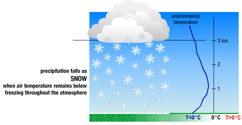
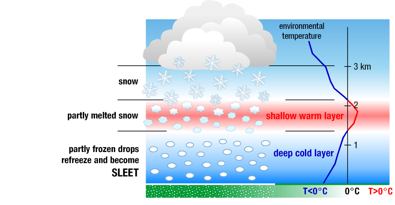
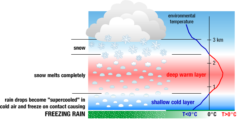
Winter storms present particular forecasting challenges because small temperature variations can dramatically change precipitation type. According to the UCAR Center for Science Education, "Winter storms begin with moist air rising up into the atmosphere, which is necessary for cloud formation and precipitation just like for other types of storms." The key difference is cold air—below-freezing temperatures at various atmospheric levels determine whether precipitation falls as snow, sleet, or freezing rain.
Snow forms when the entire atmospheric column from cloud to ground remains at or below freezing. Snowflakes develop as ice crystals in clouds, clumping together as they fall. Sleet occurs when snowflakes partially melt while passing through a warm layer of air, then refreeze into ice pellets before reaching the ground. Freezing rain happens when snowflakes melt completely in a warm layer, becoming liquid rain that freezes upon contact with cold surfaces at ground level. The National Weather Service defines an ice storm as having at least 0.25 inches of ice accumulation, which can cause significant damage to trees and power lines.
Different types of winter storms present varying hazards. Blizzards combine falling or blowing snow with winds exceeding 35 mph, reducing visibility to near-zero. Lake-effect storms develop when cold air moves over warmer lake waters, picking up moisture that falls as heavy snow downwind. Ice storms create hazardous driving conditions and can cause widespread power outages as ice accumulates on trees and power lines.
Modern Forecasting Tools: How Meteorologists Predict Winter Storms Today
The October 2024 winter storm in Fairbanks, Alaska, demonstrated modern forecasting capabilities. Meteorologist Bobby Bianco accurately predicted "cement falling from the sky"—heavy, wet snow that would change to rain. As he explained to the Alaska Science Forum, "They were all showing similar results... We had confidence it was going to be a big storm with snow changing to rain." The European Centre for Medium-Range Weather Forecasts model, which performs a million billion calculations per second, provided crucial guidance alongside other global models.
Today's forecasters use ensemble methods—running multiple model simulations with slightly different initial conditions—to quantify uncertainty. As Frontiers for Young Minds explains, "If all suggestions from the weather models are similar, then meteorologists can be quite certain of the future weather, but if the models tell different stories, they know that the forecast is uncertain." This probabilistic approach helps communicate risk, allowing emergency managers and the public to prepare for various scenarios.
Dual-polarization radar represents another major advancement. The NOAA National Severe Storms Laboratory developed this technology, which sends both horizontal and vertical radar waves to determine precipitation type. "With this information," notes NSSL, "forecasters can clearly identify rain, hail, snow, ice pellets and even bugs. If they know what type of precipitation is falling, they will make more accurate estimates of how much to expect."
The Future of Weather Forecasting: AI and Improved Accuracy
Weather prediction continues to advance with artificial intelligence and machine learning playing increasingly important roles. Researchers are developing AI models that can identify patterns in massive datasets more efficiently than traditional physics-based models. These systems may eventually provide earlier warnings for severe weather events and improve long-range seasonal forecasts.
Ongoing improvements in satellite technology promise higher-resolution data with more frequent updates. The growing network of ground-based sensors, including those on commercial aircraft and ships, will fill observational gaps, particularly over oceans. As computational power increases, models will operate at finer spatial resolutions, better capturing local variations in weather.
Despite these technological advances, the human element remains essential. Meteorologists must interpret model output, communicate uncertainty effectively, and apply local knowledge that computers cannot replicate. As forecasting improves, the focus shifts toward better communicating risks and helping communities prepare for extreme weather events in a changing climate.
Key Points to Remember About Weather Forecasting and Winter Safety
Understanding weather forecasting and winter storm formation helps us make informed decisions during severe weather. Remember these essential points:
- Modern weather forecasts combine observations from multiple sources, computer model simulations, and human expertise.
- Winter precipitation type (snow, sleet, freezing rain) depends on temperature profiles through the atmosphere.
- Forecasting accuracy has improved dramatically, with 4-day forecasts now as reliable as 1-day forecasts were 30 years ago.
- Always check official forecasts and warnings from the National Weather Service during winter weather events.
- Prepare for winter storms by having emergency supplies, avoiding unnecessary travel, and following local guidance.
As weather prediction technology continues to advance, society benefits from earlier warnings, more accurate forecasts, and better preparation for the winter storms that impact communities across the country each year.