
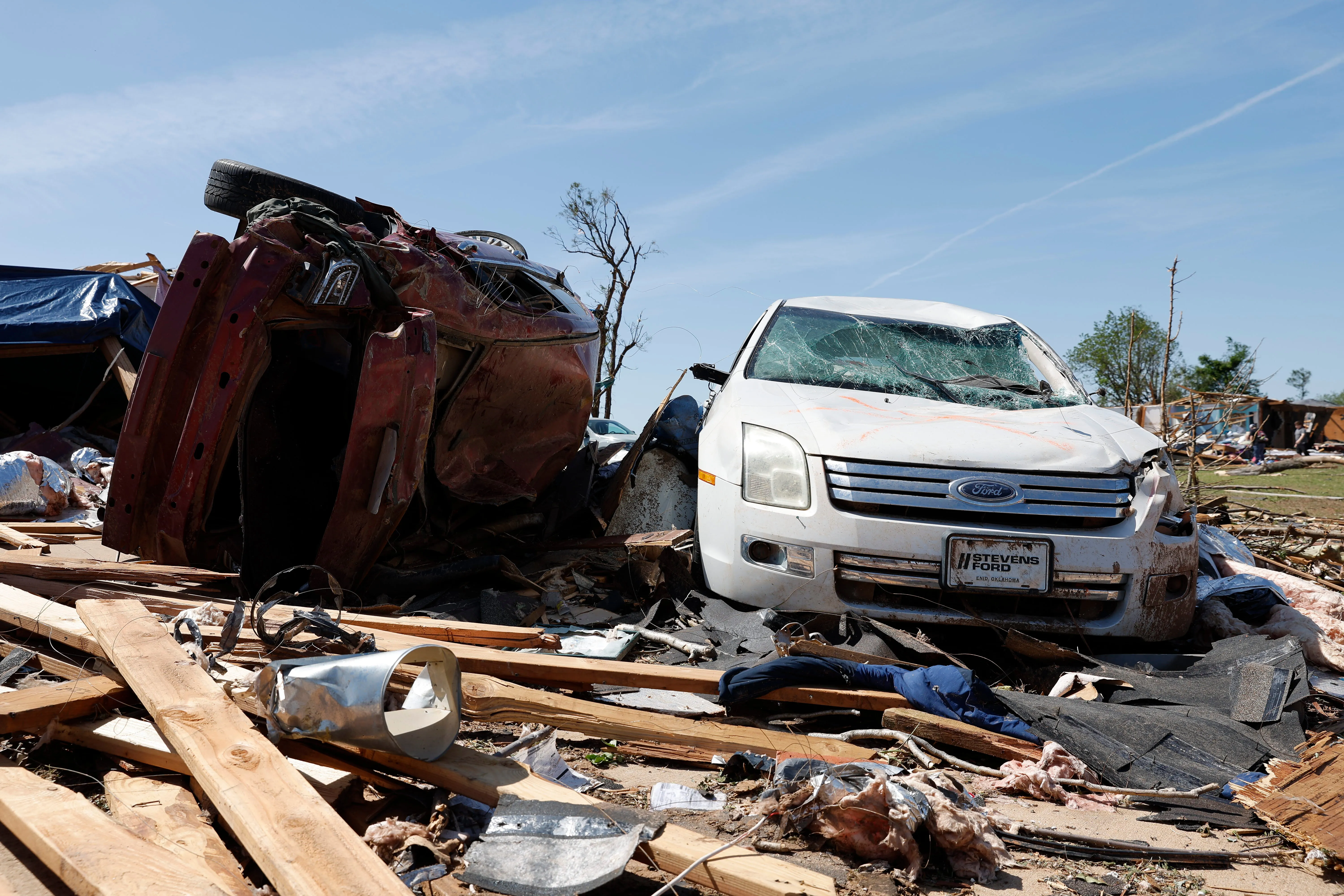
On the evening of April 23, 2026, a powerful EF-4 tornado tore through the city of Enid, Oklahoma, destroying dozens of homes and leaving a path of devastation across the southern part of the city. With estimated wind speeds of 170 mph, the twister carved through the Gray Ridge neighborhood, damaged Vance Air Force Base, and left 40 to 50 homes completely destroyed. Remarkably, no fatalities were reported, and only minor injuries were sustained — a fact that officials have described as nothing short of miraculous.
This destructive event offers a powerful opportunity to understand the science behind tornadoes: how they form, what determines their strength, and why some storms become so devastating while others remain relatively weak.
The Science of Tornado Formation: How Destructive Twisters Are Born
Tornadoes are among nature's most violent phenomena, but they don't appear from clear skies. According to the UCAR Center for Science Education, tornadoes only form when a thunderstorm has a very particular combination of winds and atmospheric conditions. The process begins inside a large thunderstorm, typically a supercell — a type of storm characterized by a rotating updraft called a mesocyclone.
Here's how the sequence unfolds: Warm, humid air near the ground rises rapidly, while cooler, drier air in the upper atmosphere sinks. This collision creates instability. When wind speed and direction change with altitude — a condition known as wind shear — the rising air begins to spin horizontally. Strong updrafts within the thunderstorm then tilt this rotating air from horizontal to vertical, creating a column of spinning air that can extend downward toward the ground.
The downdraft plays a critical role in tornado formation as well. Scientists describe how the downdraft helps "squeeze" the air near the ground up into the updraft, tightening the rotation and causing the funnel cloud to intensify. When this rotating column of air touches the ground, it officially becomes a tornado.
The EF Scale Explained: What Makes a Tornado "EF-4"
The National Weather Service rated the Enid tornado as an EF-4 on the Enhanced Fujita Scale — but what does that actually mean? The EF Scale, which became operational on February 1, 2007, is the standard method used by meteorologists to classify tornado intensity based on the damage a tornado causes to structures and vegetation.
The scale ranges from EF0 to EF5, with each level representing a range of estimated wind speeds and corresponding damage potential:
- EF0 (65-85 mph): Light damage — some shingles peeled off, gutters damaged, tree branches broken
- EF1 (86-110 mph): Moderate damage — roofs severely stripped, mobile homes overturned, windows broken
- EF2 (111-135 mph): Significant damage — roofs torn off frame houses, mobile homes demolished, large trees snapped
- EF3 (136-165 mph): Severe damage — entire stories of well-constructed houses destroyed, trains overturned, heavy cars lifted
- EF4 (166-200 mph): Devastating damage — well-constructed houses completely leveled, cars thrown significant distances
- EF5 (over 200 mph): Incredible damage — strong-framed houses leveled off foundations, automobile-sized missiles fly through the air
According to the National Weather Service, the EF-4 rating assigned to the Enid tornado places it in the "violent" category — one step below the maximum possible rating. NWS damage survey crews found EF-4 damage in multiple locations across south Enid, with some areas completely flattened. This was the first EF-4 tornado in Garfield County since April 26, 1991, and the first EF-4 in Oklahoma since 2024.
Timeline: How the Enid Tornado Unfolded
The storm system that produced the Enid tornado was part of a larger outbreak that generated more than 20 tornadoes across the Plains, from Oklahoma to Iowa, along with over 140 reports of hail and damaging winds.
Thursday, April 23, 2026: Throughout the afternoon, atmospheric conditions became increasingly favorable for severe thunderstorm development across northern Oklahoma. Warm, moist air surged northward from the Gulf of Mexico while a strong upper-level disturbance moved across the region — the classic recipe for tornado formation.
8:22 p.m. CDT: The National Weather Service in Norman, Oklahoma issued a Tornado Emergency for southeast Enid, describing a "confirmed large and destructive tornado" located near Vance Air Force Base. This is the highest level of tornado alert and is only issued when a severe threat to human life is imminent and catastrophic damage is occurring.
Evening hours: The tornado touched down south of Enid and moved through the Gray Ridge neighborhood, a residential area on the city's southern side. The twister damaged commercial buildings, turning them into piles of twisted metal and splintered wood. Homes were pushed off their concrete foundations. Utility poles were knocked down, and power lines became wrapped with debris.
Overnight: Search and rescue operations began immediately. Enid Mayor David Mason confirmed that some residents were trapped in their homes by debris and had to be rescued. The Garfield County Sheriff's Office reported that phone lines were down due to tornado damage. Vance Air Force Base closed until further notice, reporting that all personnel were accounted for with no injuries.
Friday, April 24, 2026: NWS damage survey teams confirmed the EF-4 rating. Governor Kevin Stitt toured the damage. Vance Air Force Base reopened for essential personnel. Communities began cleanup efforts.
Why the Enid Tornado Was Particularly Dangerous
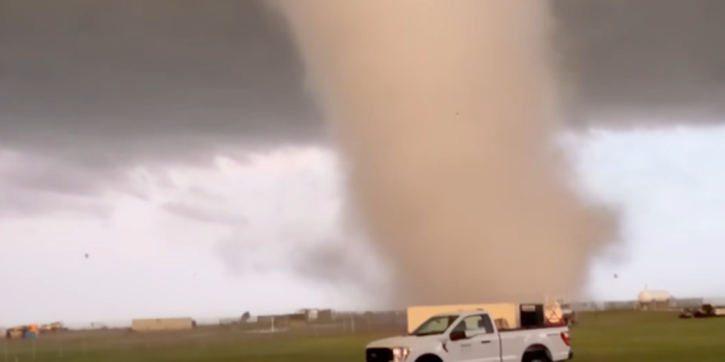
Several factors made the Enid tornado especially destructive. First, the storm moved through a densely populated residential area. The Gray Ridge neighborhood, where the most severe damage occurred, is a well-established community with numerous homes. Second, the tornado was described by FOX Weather meteorologists as a "stove-pipe" tornado — a visual term for a wide, cylindrical-shaped funnel that often indicates an intense, well-developed circulation.
FOX Weather Meteorologist Haley Meier, who was positioned near Enid during the storm, described the scene: "I saw a violent video of that active, violent stove-pipe tornado, and it was fairly stationary for a good bit. That tornado held on for as long as it could." A stationary or slow-moving tornado can inflict even more damage because it spends more time over each location, increasing the potential for structural failure.
According to the CBS News report, local resident Amy Kuntz was on the phone with her daughter when the tornado hit. "She said, 'I don't know what to do.' And then I was like, 'Get in the bathtub.' So she got in the bathtub and not even a minute later, she's like, 'Mom, the roof's gone,'" Kuntz told KFOR-TV.
Where Things Stand Now: Recovery Underway
As of Friday, April 24, the city of Enid has begun the long process of recovery. Mayor David Mason confirmed that homeowners in the Gray Ridge area have been allowed to return to their properties to salvage belongings and assess damage. "The support from our community has been remarkable. Local businesses have offered equipment and labor, residents have opened their doors, and supplies have poured in already," Mason said. "This is who Enid is in challenging moments — we continue to show up for one another."
However, forecasters warned that additional severe weather could complicate recovery efforts. NOAA's Storm Prediction Center placed Enid under a Level 3 out of 5 risk of severe thunderstorms for Saturday, emphasizing the importance of clearing debris before the next storm system arrives.
What the Enid Tornado Teaches Us About Severe Weather
The Enid tornado serves as a stark reminder of the power of nature and the importance of understanding severe weather. The fact that no fatalities occurred despite 40 to 50 homes being destroyed is a testament to the effectiveness of modern tornado warning systems, including the Tornado Emergency alerts issued by the NWS.
Tornadoes remain difficult to predict with precision, but advances in radar technology and storm modeling continue to improve warning times. Meteorologists now have the ability to detect the rotation within a thunderstorm before a tornado forms, giving communities precious minutes to seek shelter.
Key Takeaways: Everything You Need to Know
- Tornadoes form when warm, moist rising air meets cooler, drier air in a thunderstorm, creating a rotating column that extends to the ground
- The Enhanced Fujita (EF) Scale rates tornadoes from EF0 to EF5 based on wind speed and damage severity
- The Enid, Oklahoma tornado was rated EF-4 with estimated winds of 170 mph — the first EF-4 in Oklahoma since 2024
- 40-50 homes were destroyed but miraculously there were no fatalities and only minor injuries
- Tornado warnings and emergency alerts save lives — the NWS issued a Tornado Emergency before the storm hit Enid
- Even after a tornado passes, risks remain — debris cleanup, power outages, and additional severe weather can complicate recovery